Goula Gorge
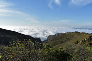
Goula Gorge stretches through the Asterousia Mountains, starting south of Kapetaniana and ending at the seaside settlement of Agios Ioannis of Kapetaniana. It is one of the most impressive and wild gorges of southern Crete, set within a landscape of steep slopes, fragile rock formations, and strong geological interest. Like the neighboring gorges of the Asterousia range, traversing it along the riverbed is impassable without specialized canyoning training and equipment. For canyoning enthusiasts, Goula Gorge offers a demanding and thrilling experience. It is approximately 1,700 meters long and includes 18 rappels, the highest reaching about 55 meters.
A full descent through the gorge takes around 4.5 hours and is usually done during the dry season, as the gorge is typically without water. At the same time, there is a hiking route that follows the eastern slopes of the gorge along a marked trail with protective sections. The hike lasts about 2.5 hours and can start either from Kapetaniana or from the antenna point on the road to Agios Ioannis. Although not technically difficult, it requires caution due to the downhill gradient, loose gravel, and uneven terrain.
The gorge takes its name from Goula, the most important spring in the area, which supplies water to Agios Ioannis. In its upper section, vegetation and pine trees are encountered, while further down the landscape becomes predominantly wild and rocky. In the second half of the route, the pine-covered ground and the view toward the blue sea create an impressive setting, with the hike ending at the clear waters of Agios Ioannis.
*The photograph is sourced from the official website of the Asterousia UNESCO MaB Biosphere Reserve.